
|
|
posted: December 3, 2022
tl;dr: Great views abound, but getting to the top takes preparation and effort...
When I travel to a new city, I like to go to the top of the tallest building to both enjoy the view and to orient myself relative to other landmarks. In Phoenix and the Valley of the Sun, the best place to view the entire valley is from the top of Camelback Mountain. Another option is Piestewa Peak, which is closer to downtown Phoenix although not quite as high as Camelback Mountain. The Summit Trail up Piestewa is a bit easier than the Cholla Trail up Camelback, but the views from the peak of Camelback are worth the added difficulty.
My wife and I have hiked the Cholla Trail twice: once shortly after we moved to the Valley, and a second time last weekend, on the Friday after Thanksgiving in order to Opt Outside on Black Friday. We probably would have done it more often but it was closed for more than two years for extensive renovations. The steepness and difficulty remain, but the improvements are welcome. The trailhead was relocated out of a residential neighborhood to Invergordon (a.k.a. N. 64th Street), which no doubt makes the neighbors happier. The entrance gate is locked until just before sunrise when a park ranger shows up. Could you hop the fence and do a pre-dawn hike to the top to witness sunrise from the peak? People certainly do so.
Heed the warnings at the bottom
The most important improvement, from a safety perspective, is the closely-spaced blue reflectors that now mark the steep, rocky, upper portion of the trail. In the past this portion of the trail was marked with blue paint, which faded in the intense summer sun. On our prior hike four years ago, before the reflectors, my wife and I lost the trail coming down and ended up at the top of a small cliff, which was a pretty strong indication that we needed to turn around and try another descent. The reflectors should reduce the number of hikers that go off-trail, get into trouble, and need to be rescued. People do die on Camelback Mountain, and rescues are a common occurrence.
Besides being observant to stay on the trail, here are my recommendations to avoid being rescued or worse:
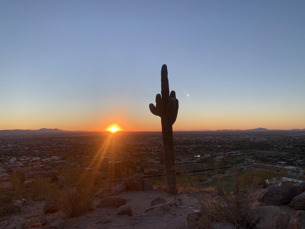
An oft-photographed saguaro, at sunrise
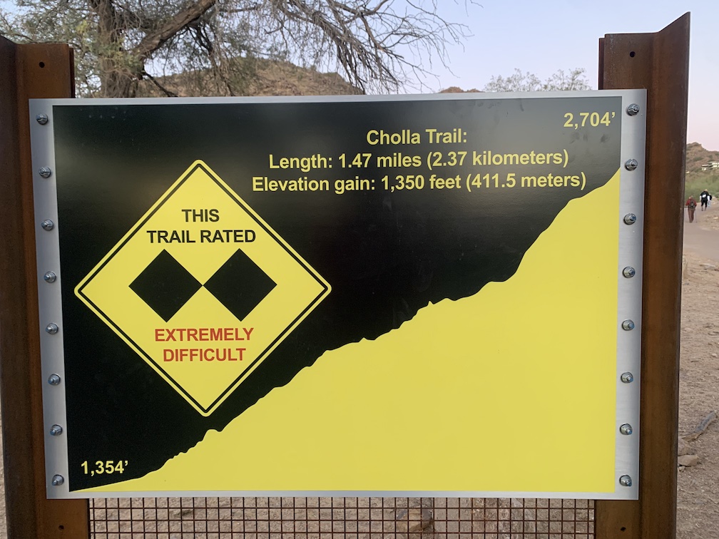
A short distance from the trailhead there are restrooms, with water, and a drinking fountain, although you should already have brought water in case the fountain isn’t working. Next to the restrooms you’ll find signage warning you about the difficulty of the trail, the need to stay hydrated, and warnings about heat exhaustion. The Cholla Trail is rated as a double black diamond (“Extremely Difficult”) trail, the same rating ski resorts apply to their steepest, most dangerous trails. The rating is not a joke: Cholla Trail is only for experienced hikers in reasonably good physical shape. On the same scale climbing Mount Everest would rate ten black diamonds, however do not take Cholla Trail lightly.
The very beginning of the trail, however, is quite civilized, with a clear wide path and steps built into the trail in several places. One option for casual hikers who want a souvenir is to hike up to a prominent lone saguaro cactus and take pictures of themselves next to it, with a view of the east valley in the background. Turn back at any point on the trail if it is becoming too challenging for you: you will not be alone in doing so.
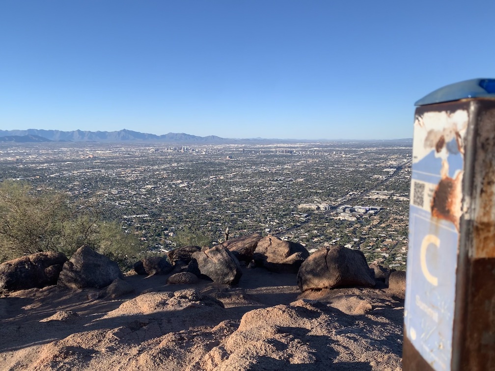
Camelback Mountain summit view, looking southwest towards Phoenix
Above trail marker 25 is where Cholla Trail gets steep, so if you don’t like how the trail transitions beyond that point, it’s best to turn back: you’ll still have enjoyed some great views and photo opportunities. The trail beyond features steep, rocky sections where you’ll need to use all four limbs (both hands and feet) to make progress, although no technical mountain climbing techniques or tools are required and you will not be forced to support your entire weight with your arms. The rock never becomes vertical but it gets close, and there are some steep sections where you will need to exercise caution in order not to fall backwards or slip down. It’s nothing as challenging as your local rock climbing wall, but this is where Cholla Trail gets close to the boundary between being a “hike” versus a “climb”.
If you make it to the top, you will be rewarded with a 360 degree view of the Valley of the Sun. Take your pictures, and enjoy the company of your fellow summiteers. See how many valley landmarks and sites you can find. Be careful coming down, and don’t hesitate to crab walk.
The Cholla Trail meets the Echo Canyon Trail at the summit: the Echo Canyon Trail is the other Camelback Mountain summit trail, which starts on the northwest side of Camelback Mountain. There will be some experienced hikers doing a full through hike from one trailhead to the other, and also some especially athletic folks doing back-to-back through hikes. But even the best trail runners will have to slow their pace on the steep upper portions of the trails. My wife and I have yet to hike the Echo Canyon Trail: it is still on our bucket list.