|
|
posted: July 13, 2024
tl;dr: How often do you find a great motorcycle road with views of one of the Seven Natural Wonders of the World?...
The much more popular South Rim of Grand Canyon National Park is on the plain of the Colorado Plateau, at around 7,000 feet elevation. Being a plain, the only topographical reason to put in curves on the park road is to follow along the edge of the canyon. The South Rim features some iconic views, but there are many people in cars and buses seeking those same views. You can easily ride a motorcycle to the South Rim, but the park road is not a great motorcycle road.
Ask anyone who has journeyed to both the South Rim and the North Rim, and they will tell you that the much more remote North Rim is even more spectacular. The topography is more varied, with changes in elevation and natural barriers that were best avoided when building the park access roads. One of the viewpoints, Point Imperial, is at nearly 9,000 feet elevation, providing an even higher view of the canyon carved by the Colorado River roughly 7,000 feet below. You literally look down upon the South Rim of the Canyon, whereas when you are on the South Rim looking north, you can see nothing beyond the northern upper edge of the canyon.
It took me nearly sixty years, but I finally made it to the North Rim. It is not easy to access it from the major population centers of Arizona, as there are only a few ways to cross the Colorado River. A huge canyon will create that limitation. On my HOG chapter’s journey to the North Rim we spent the night in Page. The next day we crossed the Colorado at the Glen Canyon Dam bridge, went on to Kanab, Utah, and then turned southeast to the North Rim. On the return ride we crossed at the Navajo Bridge after riding along the impressive Vermillion Cliffs. Those are the two options for coming from the east and south sides of the canyon.
The elevation of the North Rim makes it inaccessible in another way. Whereas the states to Arizona’s north and northeast, Utah and Colorado, are renowned for their snow, most people don’t realize that Arizona also gets lots of snow at higher elevations. At 9,000 feet elevation in places, the long access road to the North Rim, Arizona State Highway 67 (AZ 67), qualifies as one of those snowy places. Since AZ 67 only goes to one place, the North Rim, it should have a large “Dead End” sign when you turn onto it from U.S. Highway 89A. Because AZ 67 serves no other purpose, the access road into the park is only open for five non-snowy months of the year, from May 15 to October 15. You need to time your North Rim trip accordingly.
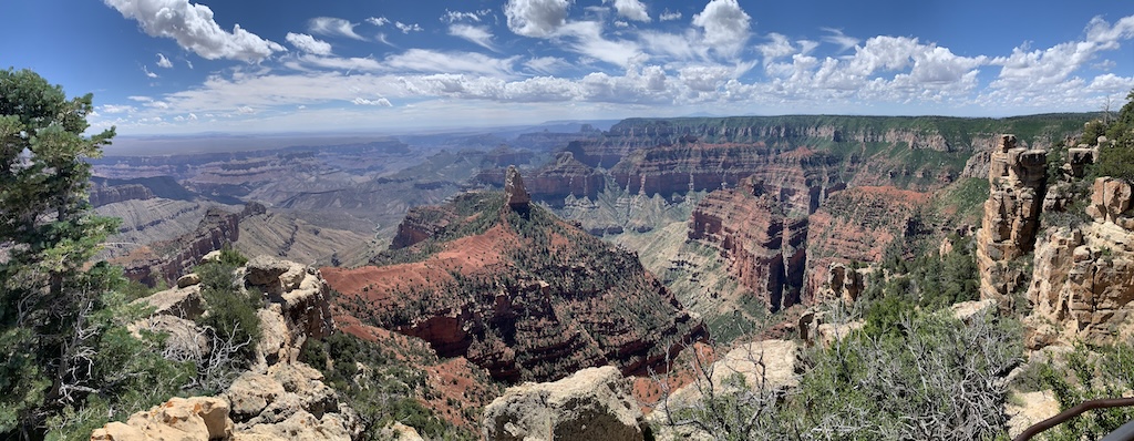
Point Imperial on the North Rim of Grand Canyon - the South Rim is the plain below the clouds on the left
AZ 67 is itself a fun motorcycle road. It features wide bends as it winds through some elevation changes, passing through pine forests, grassy alpine meadows, and some ponds. There is very little traffic. If you get lucky, you may see some wildlife. We saw deer when we stayed outside the national park at the Kaibab Lodge, but not while we were riding. If you came from the Valley of the Sun, the temperatures are much cooler, with lows around 60 degrees Fahrenheit in the morning. At night there are great views of the stars, as there is no light pollution.
Outside and inside the park, there are areas that are growing new vegetation after having recently burned. I am a big proponent of the “let it burn” forest management philosophy for areas like the North Rim that are far from any human settlements. A forest experiences its own lifecycle, and suppressing fires causes the forest to languish in its fully mature state, building up its load of burnable wood and debris until it cannot be suppressed any longer, resulting in a huge conflagration. I did not shed a tear for the burned areas of the North Rim; they are evidence that Mother Nature is doing her job.
The real treat awaits motorcyclists after entering the park. AZ 67 heads to the North Rim lodge, but after the park entrance there is a left for Cape Royal Road. Cape Royal Road functions as the access road for the areas of the park to the east of the lodge. There is a leg that heads to the highest viewpoint in the park, Point Imperial, while the main road continues on past several other amazing viewpoints and ends at Cape Royal, where the famous Angel’s Window rock formation can be accessed after a short hike. The only way out is to retrace the road in the other direction, which doubles the pleasure as you’ll be riding it twice.
The road is in fantastic shape, and features plenty of curves which are tighter than AZ 67. It’s not a highly technical, twisty road, but you’ll definitely want to pay attention. Many of the curves are blind, and you’ll want to mind your speed else you come upon a carful of tourists, although there was very little traffic when we rode it on a Saturday. The road is restricted to vehicles 22 feet or less, which eliminates large RVs. It’s narrow, there is no shoulder, and the lush vegetation often grows into the road a bit. The high alpine scenery is gorgeous. In a few places the road gets close to the rim, and as you navigate a curve, you may catch a glimpse of Grand Canyon through the greenery.
You’ll definitely want to stop at the viewpoints to take in the best rim views anywhere in the canyon. Grand Canyon features many side canyons that feed into the main channel of the Colorado River, and Cape Royal Road provides access to several of the most spectacular. The Point Imperial and Cape Royal viewpoints are not to be missed. At Cape Royal you can take a short trail to the top of Angel’s Window, which provides the sensation of being in the canyon, rather than looking into it from the rim.
After riding all of Cape Royal Road in both directions, we ended our visit to the North Rim at the lodge, which has a fine restaurant and outdoor patios. There are cabins at the North Rim Lodge, but reserving them is a challenge, which is one reason we stayed outside the park. There are very few facilities at the North Rim, which is the other main downside besides the remoteness. But the remoteness and lack of facilities means many fewer people.
Cape Royal Road is a road like no other in the world. It is best experienced on a motorcycle. I didn’t see any bicyclists, and the narrowness, curves, and lack of shoulders would make it quite dangerous on a bicycle. On a motorcycle, however, it is heaven.
Related post: Great motorcycle roads: Arizona 89/89A Wickenburg to Flagstaff
Related post: Great motorcycle roads: Hawaii 550/552 Waimea Canyon, Kaua`i
Related post: Great motorcycle roads: The Devil's Highway, US-191 Clifton to Springerville, Arizona